|
36 Amory St., 1910
Designed in 1905 by Charles Adams Platt for Henry Howard.
[Source: Smithsonian]
|
 |
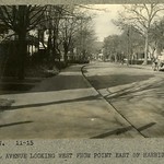
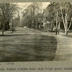
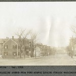
St. Paul St. at Aspinwall Ave., Looking Southwest Toward Harvard St.
Circa 1915. 79 Aspinwall foreground left. Note horses getting water at the pump with an early automobile in the background.
[Source: Olmsted]
|
 |
Aspinwall Ave., 1920s
Looking east from Harrison St. 194 Aspinwall Ave is the first house on the left.
|
 |
Aspinwall Ave. & Harrison St., November 1915
Looking west. Horse-drawn cart is in front of #194, Harrison St. comes in after that.
[Source: Olmsted]
|
 |
Aspinwall Ave. & Toxteth St., November 1915
Looking west just before Toxteth St. #168 Aspinwall Ave. is the first house on the right.
[Source: Olmsted]
|
 |
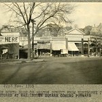
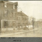
Beacon St. Near the Boston Line, February 1921
North side looking east toward St. Mary's St. Left to right: #1032 (no longer standing); #1022, The Ginter Co., groceries (still standing); #1020, the first brownstone (no longer standing); #1018, the only brownstone still standing; #s 1016, 14, 12, 10, 8, 6, 4, 2 have all been demolished.
[Source: Olmsted]
|
 |
Beacon St. Just West of Carlton St., 1-Jul-1909
Looking east toward Boston. #1067 Beacon St. near foreground on the far right, midway between Hawes St. and Carlton St. On the left is the building comprising 1056-1064 Beacon St. All still standing.
[Source: Smithsonian]
|
 |
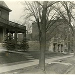
2 Charles St.
Sears family home, looking north. Left, rear: Buildings on Pleasant St. on property owned by James Stearns.
[Source: Smithsonian]
|
 |
2 Charles St.
Sears family home. Beacon St. to the left. Only structure in photo that is still standing.
[Source: Smithsonian]
|
 |
Charles Stearns House, 265 Harvard St.
Looking west from the Thomas Sears house on Charles St. Foreground right: Charles Stearns house. Foreground left: out-housing of Charles Stearns. Far distance: Aspinwall Hill. The large mansion at the top of the hill with the tall spire was built by Clarence Esty, part of a group of Esty houses that have since been replaced by Schick Park. The spire was an observation tower equipped with a high-powered telescope that enabled detailed viewing of distant scenes.
Harvard St., south of Beacon St., runs roughly left to right in the middle of the picture.
[Source: Smithsonian]
|
 |
Beacon St. Looking West Toward Coolidge Corner
In the center is the S. S. Pierce Building with the old cupola that was later destroyed in a fire. To the right, the James Whitney house is partially visible on the northwest corner of Pleasant St.
[Source: Smithsonian]
|
 |
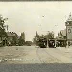
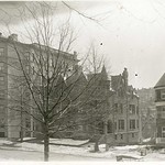
Coolidge Corner and Corey Hill, circa 1897
This is a rare photo showing a stage in the evolution of the old Coolidge & Brother store after the 1887 widening of Beacon St. The original store, which had been taken over by Merrill Brown in 1884, was purchased in 1892 by the S.S. Pierce Company which then constructed the new S.S. Pierce Building seen today in 1898-99. Also visible are the large homes lining Summit Ave.
[Source: Smithsonian]
|
 |
Coolidge Corner
[Source: Olmsted]
|
 |
Harvard St. at Babcock St., circa 1912
Looking south toward Coolidge Corner. Babcock St. foreground left.
|
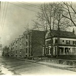 |
Park St., February 1921
Looking northest. Apartments #75-83 still standing. House at 71 Park is no longer standing.
[Source: Olmsted]
|
 |
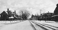
1575 Beacon St., March 1921
[Source: Olmsted]
|
 |
Beacon St., Washington Sq., November 1915
[Source: Olmsted]
|
 |
Regent Circle, Circa 1911
|
 |
Brookline Ave, December 1916
Looking south. Park Avenue Terrace on the left. Pearl St. on the right in the foreground. Washington St. is visible in the far distance.
[Source: Olmsted]
|
 |
Brookline Ave. & Park Drive Terrace, December 1916
Rear of 107 and 105 Brookline Ave., no longer standing. Rear, all still standing, left to right: Dutch House, brick apartment buildings on Aspinwall Ave.
[Source: Olmsted]
|