The views were dramatic and sweeping, the air fresh and clear, and the land was lush and spacious. It was these attributes of the High Street hill that proved to be an irresistible draw for some of Boston's creative and professional elite. Rising up between Brookline Village and Jamaica Pond, the hill overlooks Leverett Pond, with Boston in the distance. Endowed with health-giving openness, the neighborhood on the hill was a welcome antidote to the crowded, dirty city; and yet, when duty called, a frequent train to Boston could be caught in nearby Brookline Village. The newcomers hired Boston's most well-respected architects to design and build homes in the era's most popular styles. Over time, and through self-selection, a close-knit community evolved on the hill, one known for its cultured sociability. Through the years, many leaders in politics, education, and science came to live on the hill, and in the early 20th century, it was named Pill Hill in reference to the many doctors who called it home.
Today, the attractive neighborhood still has the feel of an enclave, set apart from its surroundings. The small lots, picket fences, front porches, and detailed façades embellish the neighborhood with visual richness, and create a welcoming human scale. Homes are similar in size and have uniform setbacks, resulting in a feeling of safety, enclosure, neighborliness, and commonality.
Pill Hill was one of America's very first suburbs, and like others of its kind, it evolved out of a convergence of cultural and economic forces that swept the nation as it recovered from the Civil War. Waves of immigrants were pouring into the cities to work in the surging industrial revolution. Crowding, pollution, and public health epidemics were just some of the results. The deteriorating conditions precipitated a large exodus of those who could afford it, namely the upper and middle classes. Visionary thinkers sought alternatives to the close-grained urban grid and advocated for the health benefits of living in a more decentralized pattern, made possible through the advance of transportation technologies.
High Street Hill & Samuel Philbrick
The High Street hill did not become part of Brookline until 1844, when the land east of High Street extending to Pond Street was annexed from Boston, with the Muddy River becoming a logical dividing line between the two municipalities. Of particular renown amongst the Hill's early residents was Samuel Philbrick, Brookline's famous abolitionist. His home at 182 Walnut Street had been a stop on the "underground railroad," giving safe harbor to escaped slaves making their way to the free North. Later on, with his son Edward, a civil engineer, he developed his estate's land, encompassing Upland Road, Maple Street, and the middle part of Walnut Street, after consulting with F.L. Olmsted on a preliminary design.
Brookline Land Company
The Brookline Land Company formed in 1860 and purchased 80 acres of land lying between Brookline Village, Jamaica Pond, High Street, and the Muddy River. To set the tone of the new development, the land company sold its building lots with strict deed restrictions designed to prevent "any occupation or erection of any building which could work injury or annoyance to residents." Many individuals involved with the Brookline Land Company were also members of a church dedicated to the teachings of Emanuel Swendenborg, and in 1861-62, they built a church at High and Irving Streets which today is the Latvian Lutheran Church. By 1876, 30 acres of the company's land had been sold for development. Of the many outstanding examples of period architecture on the hill, one of the most highly developed is the Stanwood House at 76 High Street. An exuberant example of Queen Anne embellishment, the entire façade reads like an intricately carved piece of exotic furniture. The neighborhood's historic architecture is protected through inclusion in both a Local Historic District and a National Register District.
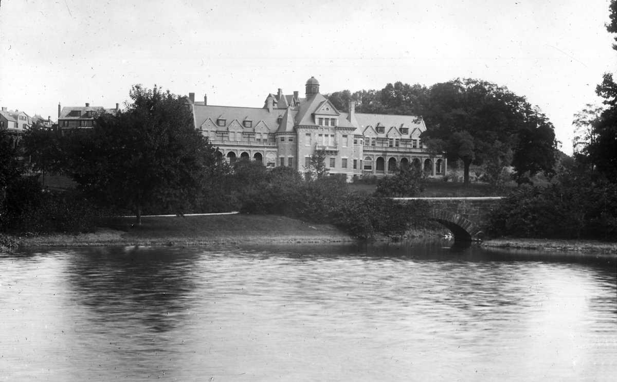
The hill's eventual street and lot layout is an amalgam of designs, incorporating part of Olmsted's plan for the Philbrick estate, whose legacy can be seen in Upland Road and the Philbrick Square it surrounds. Snaking its way up the north-facing slope is Walnut Place, a private dead-end road that gives access to some of Brookline's most secluded homes. The Brookline Land Company coordinated with F. L. Olmsted as he designed the Emerald Necklace, ultimately selling some of its land to make Leverett Pond and Olmsted Park. It was of course in their best interest to do so, as Olmsted's efforts transformed a marshy, flood-prone, disease-breeding, sprawling tributary into an attractive, well-contained river course and linear park. Almost simultaneously with this transformation, the Free Hospital for Women was constructed (in 1894-95) on a site overlooking the river, taking advantage of the abundant light and air on the slope behind Edgehill Road. Today, the hospital buildings and grounds have been converted into a luxury condominium complex.
The Point
The Point refers to the area below the south slope of Pill Hill, bounded by Jamaica Pond and the Muddy River. What began with the relocation of several modest homes onto Hart Street in 1871, quickly developed into a neighborhood of multi-family and modest single-family homes. The location of the Town stables at Kendall and Cypress Streets and the West End Railroad Company's car barn at the corner of Franklin and Cypress Streets (where Robinson Park is today) set a development trend in motion. These more "industrial" land uses made the surrounding lands less expensive. The Point ultimately became home to many working-class Irish Americans. The area's many triple-deckers with their bay windows and wide front porches create a uniform and pleasing visual rhythm. The neighborhood's homes have a consistency of setback, design, and materials which, along with variations of color and décor, give the short, narrow streets in the Point an intimate and homey atmosphere. The Harry Downes Field is gathered up in the encircling arms of the neighborhood, with many of the surrounding homes' porches overlooking its cooling green expanse.