PROCEEDINGS
OF THE
BROOKLINE HISTORICAL SOCIETY
AT THE
ANNUAL MEETING, JANUARY 26, 1909
BROOKLINE, MASS.
PUBLISHED BY THE SOCIETY
MCMIX
OF THE
BROOKLINE HISTORICAL SOCIETY
AT THE
ANNUAL MEETING, JANUARY 26, 1909
BROOKLINE, MASS.
PUBLISHED BY THE SOCIETY
MCMIX
A Paper Read before the Society by Charles F. Read, May 27, 1908.
Before the introduction of the steam railroad in the nineteenth century, it was the custom in the new world, as in the old, to travel by stagecoach or private carriage on the roads which connected the towns and villages which lay scattered on the route. At intervals on these roads could be seen stone posts suitably inscribed, which were called milestones. They were welcome sights to travellers, when beginning in gay mood a day's journey; a more welcome sight at nightfall when one was found to be near a hospitable tavern where food and shelter were ready for tired traveller and more tired beast.
When Benjamin Franklin was Deputy Postmaster-General of the British Colonies in America, he caused many milestones to be placed on the post roads between Boston and Philadelphia to enable His Majesty's mail carriers to measure distance as they travelled on the king's business on their fleet horses. It is related of the many-sided Franklin, whom we delight to honor as a native of Boston, that he constructed a mechanical device whereby he could have his milestones placed at regular intervals on the road. He travelled in a comfortable chaise, to which his contrivance was attached. His chaise was followed by workmen travelling in a cart, from which they unloaded and set a milestone at each designated place. This invention of Franklin may be called a forerunner of the modern cyclometer and speedometer which the bicyclist and autoist attach to "wheel" or "auto" to record the distance travelled. A few of the Franklin milestones are still standing on the former post-roads between Boston and Philadelphia. One in Stratford, Conn., is marked-
F
20
Miles
TO
N H
20
Miles
TO
N H
By the time of the administration of Gov. Hutchinson, the Province of Massachusetts Bay had become well supplied with milestones, and several are still standing. Two are to be seen on the old Boston and Worcester Turnpike. One is situated in the town of Framingham at the junction of the turnpike and the road to South Framingham. It is inscribed-
23
Miles
from
BOSTON
1768
Miles
from
BOSTON
1768
It is interesting to note that within a quarter of a mile of this stone is the old Buckminster Tavern, where the three companies of Framingham militia paraded before the Battle of Lexington in 1775. The two spies sent through Middlesex County in February of the same year by Governor Gage stayed at this tavern over night and saw a parade of the Framingham men. In their report to the governor they said, after describing the parade, that "the militiamen went into the tavern and drank liquor until they were full of pot valor." The other stone is to be seen in the centre of the city of Worcester and bears the inscription-
42 Miles
to Boston
52 Miles
to Springfield
1774
to Boston
52 Miles
to Springfield
1774
These stones are probably two of many which were set in compliance with the following order of the Council of Massachusetts Bay issued in 1767, the original record being filed in volume xvi, page 239, of the Massachusetts Archives. The order reads, "To the Justices of Middlesex, Essex, York, Cumberland and Lincoln Counties. To preserve mile marks of Captain (Francis) Miller, by fixing stones at said marks. Also Suffolk, Norfolk, Hampden and Berkshire Counties." I am informed that this is the only reference to milestones in the records of the Governor's Council from 1729 to 1767.
It was customary in tavern days for a landlord to locate at a mile post on the highway, and fortunate indeed was he whose hostelry was placed at the end of a day's journey, for this ensured him a steady and profitable business. We can see in imagination the rotund figure of "mine host" as he hastens to his front door on the arrival of the evening coach, joyfully rubbing his hands together at the prospect of a good night's trade.
Landlords were permitted by authority to place milestones in front of their taverns at their own expense and were even allowed to so place such stones if the house was located to one side or the other of the proper marking-places. These private stones bore the initials of the landlord in addition to the distance inscription, and were formerly many in number. Such a stone is to be seen now in Walpole, Mass., and is inscribed-
ER
20
MILES
BOSTON
1740
20
MILES
BOSTON
1740
This stone was set in provincial days when our "forbears" lived under the King, by Ezekiel Robbins, landlord of the Brass Bull Tavern in Walpole, a famous relay house or noon rest, half way on the post road from Boston to Providence. Landlord and tavern have long since disappeared from sight, but the milestone was made of more enduring material. Banished from its former location by the widening of the highway, it now occupies a prominent position in front of the town hall in Walpole.
In these opening years of the twentieth century, as we travel through some of the highways and byways of Greater Boston, mayhap by trolley car, automobile or, best of all, by "shank's mare," we see scattered along the roadside many milestones which have come down to us from the days of which we have been speaking. They are zealously guarded today by antiquarians who delight in the study of the past, although in a practical way the present also claims their activities.
We should know something of the men to whom the people of Boston and its vicinity were indebted for placing so many milestones, and of these public-spirited citizens we must first consider Samuel Sewall, for he began the good work in
1707, two centuries ago. It is, however, only necessary to give a. brief biography of this useful and distinguished man, for all students of our local history are familiar with the life and activities of Boston's famous diarist.
Samuel Sewall, eldest son of Henry Sewall, was born in Bishops-Stoke, England, March 28, 1652, and died in Boston, January 1, 1730. He was graduated at Harvard College in 1671, and received there three years later the degree of A. M. He was an assistant of the Massachusetts Bay Colony from 1684 to 1686, and was appointed by William and Mary in 1692 as one of their first council, serving in that capacity until 1725, a period of thirty-three years. He was appointed a judge in 1692 and Chief Justice of the Province of Massachusetts Bay in 1718, resigning this last office in 1728 on account of the infirmities of age. He was also judge of probate of Suffolk County from 1715 to 1728.
Judge Sewall was married three times. His first wife, with whom he lived for forty-three years, was Hannah Hull, daughter of John Hull of Boston, the famous mint master. He married for his second wife Mrs. Abigail Tilley; his third wife was Mrs. Mary Gibbs.
Judge Sewall made the following entry in his diary on July 14, 1707: "Mr. Antram and I, having Benjamin Smith and David to wait on us, Measured with his Wheel from the Town House Two Miles and drove down Stakes at each Mile End in order to placing Stone Posts in convenient time. From the Town House to the Oak and Walnut is a Mile wanting 21 % Rods. Got home again about Eight o'clock."
Three weeks later the judge wrote: "Peter Weare set up the Stone Post to show a Mile from the Town House ends: Silence Allen, Mr. Gibbon's son, Mr. Thrasher,-Salter, Wm. Wheelers,-Simpson and a Carter assisted, made a Plumb Line of his whip. Being Lecture day, I sent David with Mr. Weare to show him where the second should be set; were only two little Boys beside."
These stones were placed on the thoroughfare we now call Washington street. One mile from the Town House, then standing on the site of the present Old State House, is at about the corner of Washington and Lucas streets. The one milestone at this location is shown on Bonner's map of Boston, which was printed in 1722, fifteen years after Judge Sewall had the stone placed in 1707. Two miles from the town house, where the second Sewall stone was set, is at about the corner of Washington and Camden streets. It is to be regretted that these two ancient marking stones are not standing today. But in the upbuilding of a city there is continued change; by such a process these stones may have found useful if not appropriate places in cellar walls. Will they ever be brought to light and reset as relics of the past?
The distinguished Paul Dudley may next claim our attention, for he cut the initials of his name deep and strong on many of the milestones which we see today.
Paul Dudley, son of Joseph Dudley, Governor of the Massachusetts Bay Colony from 1702 to 1715, was born in Roxbury, Mass., September 5, 1675, and died there January 25, 1752. He was educated for the law at the Temple in London, and returned to New England in 1702 with a commission from Queen Anne as Attorney-General of the Province of Massachusetts Bay. He was appointed a judge in 1718 and became Chief Justice of Massachusetts in 1745, holding this office until his death.
Judge Dudley was a naturalist as well as a jurist, was honored as such by membership in the Royal Society of London, and contributed material for a natural history of New England to the transactions of that society.
He married in 1703 Lucy, daughter of Col. John Wentworth of Ipswich, Mass. She died in 1756, surviving her husband less than five years.
It is easy to imagine that in the pursuit of the study of natural science Paul Dudley, the learned judge, traversed on foot the roads and lanes of Roxbury and its vicinity and then conceived the placing of his famous milestones; or he may have set them at the request of his friend Judge Sewall, whose life was then drawing to a close.
In connection with this biography of Paul Dudley it is interesting to relate what I was told by a grandson of Rev. Dr. John Pierce, the beloved pastor of the First Parish of Brookline, Mass., from 1797 until his death in 1849, a period of fifty-two years. Dr. Pierce was driving one day with his grandson, then a boy, and was calling his attention to the Dudley milestones which they passed on the way. "Remember," said Dr. Pierce, "that these stones were placed by Paul Dudley, and to fix this fact in your memory I will teach you a couplet of verse which you must always remember;
"His name on every side you see;
The very stones are marked P. D."
The very stones are marked P. D."
Many of the Dudley milestones must have been familiar to young John Pierce when as a student in Harvard College it was his custom to walk from his home in Dorchester to Cambridge at the beginning of the week and at the week's close to return in like manner.
Let us now speak of another native of Massachusetts who rose to distinction. Jonathan Belcher, son of Andrew Belcher, a councillor of Massachusetts Bay, was born in Cambridge, Mass., January, 1682, and died in Elizabeth, N. J., August 31, 1757. He was graduated at Harvard College in 1699 and then travelled in Europe for six years. Returning to Massachusetts, he became a Boston merchant and was later a representative in the General Court, a councillor, and agent of the Province of Massachusetts Bay in England.
He was appointed by the Crown in 1730 Governor of Massachusetts and New Hampshire-then under the same jurisdiction-and served until 1741, when in response to the opposition to his administration he was superseded by Gov. William Shirley. He was appointed Governor of New Jersey in 1747, and held that office until his death.
Jonathan Belcher married January 4, 1705, Mary Partridge, daughter of William Partridge, Lieutenant-Governor of New Hampshire from 1699 to 1702. She died in Boston, October 6, 1736, and in 1748, when Governor of New Jersey, he married for a second wife Mrs. Teel of London.
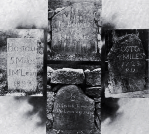
Lastly, let us study briefly the life and activities of John McLane, a Boston merchant and benefactor. He was born in Milton, Mass., in 1761 and died there October 16, 1823.
It is interesting to relate of Mr. McLane that, having failed in business late in the eighteenth century and at a later period having recovered his lost fortune, he invited his creditors to a supper at the Exchange Coffee House in Boston. At the gathering, which proved to be a joyous one, each guest found under his plate a check covering the amount of his claim, including interest.
In his will, John McLane made the Massachusetts General Hospital his residuary legatee, and that institution, then just beginning its great work, received more than one hundred thousand dollars from the estate. As a tribute of respect for this benefaction, the trustees of the hospital named the department for the care of the insane the McLean Asylum. The asylum, now great in itself, was located for many years on the Barrell estate in Somerville. It is now splendidly maintained in Waverley.
The milestones which were erected at the expense of John McLean were placed in position in 1823, the year in which he died. In fact, the work was completed after his death by his business partner, Isaac Davenport, who caused the name of J. McLean to be placed on all the stones.
The milestones which we are to consider in this paper were set on five roads which, then as now, connected Boston and some of the neighboring towns, and it is well to remember that all five lines of stones supplement the two which Judge Sewall had placed in 1707, and of which I have spoken previously. The five roads radiate from a southeasterly to a northwesterly direction from the portions of Washington and Roxbury streets which extend from Eustis street to Eliot Square.
The ancient Lower Road to Dorchester, of which I shall speak first, began at the corner of Washington and Eustis streets, and, running through Roxbury and Dorchester, ended at Dorchester Lower Mills; it followed the present Esutis, Dearborn and Dudley streets, Columbia road and Hancock and Adams streets. On this road a line of milestones was placed in the year 1734 by Gov. Jonathan Belcher "to guide the weary traveller on his way." Teel's History of Milton, published in 1889, tells us that a platway of these stones was at one time in the possession of Edward J. Baker, who died in Dorchester in 1891, and who was deeply interested in the local history of Milton.
We should find the three-mile stone in the immediate vicinity of the Hugh O'Brien School on Dudley street, Roxbury, but it has disappeared from sight.
A distance of one mile carries us to Hancock street, opposite Trull street, Dorchester, but the stone which stood there for one hundred and seventy-three years was removed in 1907 for safe keeping to the grounds of the Dorchester Historical Society at Edward Everett Square. Placed within a foot of the front wall of the ancient Blake house, the appropriate home of the society, it has found a permanent resting place. It is inscribed-
4 Miles from
Boston
Town Hous[e]
1734
Boston
Town Hous[e]
1734
The removal of a milestone from its proper location is always to be regretted, but a visit to the locality where it formerly stood, convinces us that it was by no means safe there, so rapidly is the neighborhood changing from a rural to an urban condition.
The five-mile stone should be near the corner of Adams and Park streets, Dorchester, but it cannot be found at the present day.
As we journey on for the next mile on Adams street, we see many evidences of the ancient character of this thoroughfare. We pass houses some of which were built possibly in the seventeenth century, and we see the stately elm trees bordering the way, the fast decaying fruit orchards and the primitive stonewalls which bounded the once productive farms. Before many years, all of these, with the exception possibly of the elms, will have disappeared, for there is to be seen on every side the three-story wooden apartment house.
The six-mile stone should be at about the corner of Adams street and Oak avenue, midway between Ashmont and Neponset, but we found no trace of it.
It is gratifying to record that the seven-mile stone has been cared for by the Boston authorities. It has been built into the Adams street wall of Dorchester Park and will thereby be preserved for generations to come. It is marked-
7
Miles to Boston
Town Houfe
1734
Miles to Boston
Town Houfe
1734
Descending the slope to the Neponset River, the picture of the valley and the hills beyond gladdening our eyes, we cross the river at Dorchester Lower Mills, and find ourselves in Milton, one of the fairest towns in the Commonwealth. Continuing on Adams street in that town, we find the last of the Belcher stones set in the front wall of Hutchinson Field, a metropolitan reservation. It is inscribed-
8
Miles to B Townhoufe
The Lower Way 1734
Miles to B Townhoufe
The Lower Way 1734
As we stand in front of this stone on the summit of Milton Hill and look on the beautiful picture embracing the Blue Hills and the wide expanse of Boston Harbor, we recall the three royal governors who travelled by coach and four the lower road to Dorchester in the eighteenth century. Time and again have Governor Belcher and Governor Hutchinson counted the milestones on this road as they journeyed to and fro between the Boston town house and their estates in Milton. The third chief magistrate was William Shirley, Governor of Massachusetts Bay from 1741 to 1756, succeeding Jonathan Belcher. Governor Shirley travelled continually a portion of the lower road, for his home was very near where we hoped to find the three-mile stone on Dudley street, Roxbury.
The line of milestones which were placed on the Upper Road to Dorchester, and which extend through Milton to Quincy, should be considered next. These stones are shown on an original plan which is preserved in the Massachusetts Archives. It is entitled, "Boston Town House to the tenmile stones in Quincy measures 10^ miles plus 1 rod. The Upper Road as travelled," and was drawn in 1802 by William. Taylor of Boston, Surveyor.
The total distance, 10^4 miles plus 1 rod, indicates that the stones were not placed in their proper locations, and furthermore the distances between them vary from 78 to 120 chains. But probably the traveller of the eighteenth century replied, if the locations of his milestones were questioned, "Never mind, they serve their purpose."
The third milestone was in place on Warren street, near Rockland street, Roxbury, until about the year 1871, when it disappeared during the erection of a block of dwelling houses there. This information was given me by the late L. Foster Morse, who is remembered for his interest in the local history of Boston, and especially that of Roxbury, where he resided.
One mile further on, we find at 473 Warren street, Grove Hall, the four-mile stone, which is the first Paul Dudley stone that we have considered. It is marked-
B 4
1735
PD
1735
PD
and it is interesting to say in addition that at the beginning of the nineteenth century one Bugbee had a tavern here, which was the first resting place on the road.
The next stone should be near the corner of Washington and School streets, Dorchester, but it has disappeared.
The six-mile stone, which stands at the corner of Washington and Mora streets, Dorchester, is a peculiar one, and it would be interesting to learn the meaning of a portion of the following inscription-
| Hemms
W C |
6
M to B TI |
On Adams street, Milton, which was laid out as early as 1654, we see near the railroad station the next stone, which is inscribed-
B
7
1722
7
1722
A walk of one mile on this ancient road to Quincy carries us to the location of the next stone, near the corner of Adams and Babcock streets, East Milton. The stone is inscribed-
B
8
1723
8
1723
We find one mile further, on Adams street, Quincy, just beyond the Furnace Brook metropolitan reservation, the next stone, on which we read-
B
9
1730
J N
9
1730
J N
I am informed by William G. Spear, who is an authority on the antiquities of Quincy, that the initials on this stone, J. N., are, to quote his exact words, "most likely meant for Joseph Neal."
One more mile carries us to Hancock street, Quincy, and on that thoroughfare, within sight of the church under which lie buried the second and sixth Presidents of the United States, we see what remains of the next one of this line of milestones. It is built into the stonewall in front of the Brackett house and we read on it only-
B
10
10
The eleven-mile stone formerly stood near the Adams house, at the base of Penn's Hill, Quincy, but it disappeared many years ago.
The twelve-mile stone is still to be seen on Franklin Street in Braintree as one enters the limits of that town. It is inscribed-
B
12
IM 1727 IH
12
IM 1727 IH
On the broad boulevard which we now call Blue Hill avenue, and which was called Brush Hill Turnpike from 1805 to 1870, we find the McLean milestones, which were placed in 1823. They are six in number, are constructed of hammered granite of uniform size, and the inscriptions on them are similar, with the exception of the numeral indicating the distance from Boston.
The five-mile stone is at Harvard street, Dorchester, one mile from the Dudley stone at Grove Hall. It is inscribed-
Boston
5 Miles
J McLean
1823
5 Miles
J McLean
1823
The six-mile stone is at the corner of Ormond street, Dorchester, and the seven-mile is passed as one enters the town of Milton.
Continuing, we find the three remaining McLean stones in Milton. The eight-mile stone is about a quarter of a mile south of Robbins street, the nine-mile stone is at Atherton street, and the ten-mile stone is safely set in the stone wall of a private estate not far from the boundary line between Milton and Canton.
Proceeding on Washington street, Canton, which is the continuation of Blue Hill avenue, we find a line of stones which practically supplement all three lines which we have considered thus far. They differ, however, from one another in form and material, and were placed by different persons.
At the base of Blue Hill we find a stone which was placed by Lemuel Davenport of Canton. It is marked-
12
Miles
to Boston
1774
L D
Miles
to Boston
1774
L D
One mile further is a stone set in a wall in front of a residence which was formerly the Cherry Tavern. It is inscribed-
13
Miles to Boston
1786
John Spare
Miles to Boston
1786
John Spare
John Spare, who set this stone, was a son of Samuel Spare, an early settler in Canton, and who was the first one of the name in New England. Both father and son were prominent in the Episcopal Church, or, as it was then called, the English Church, which was formed in the early days of the town.
Huntoon's History of Canton tells us that the fourteen mile stone is not standing, the author believing, when he compiled the history, that the stone lay buried beneath a modern wall.
The fifteen-mile stone stands in front of the Roman Catholic Cemetery in Canton and opposite the meeting house of the the First Congregational Parish. We cannot learn who placed it there, for the inscription merely reads-
B 15
M
M
Two miles further on the same road in Canton is a stone which bears the inscription-
B 17
M
1736
N L
M
1736
N L
This stone was set by Nathaniel Leonard, and is the first one placed in the town.
At the junction of Roxbury and Centre streets, Eliot Square, Roxbury,at which point the two last lines of milestones begin, we find the famous Dudley "Parting Stone." It bears on its faces the three inscriptions-
| DEDHAM
RHODE ISLAND |
THE
PARTING STONE 1744 DUDLEY |
CAMBRIDGE
WATERTOWN |
It is a satisfaction for antiquarians to know that this stone was saved from threatened destruction a few years ago, and that it will now be preserved for many years to come by the Boston authorities.
Centre street, on which we trace the next line of stones, runs through Roxbury, Jamaica Plain, Roslindale and West Roxbury to Dedham and beyond. The road was laid out as early as 1662, and was once called "The Middle Post Road from Boston to Hartford." The stones which we find on this ancient road were set by Judge Dudley, and four of them are in place today.
The three-mile stone is at the corner of Centre street and Highland avenue, just beyond Eliot Square, and is inscribed-
BOSTON
3 MILES
1729
3 MILES
1729
It is one mile distant from the former location of Judge Sewall's two-mile stone on Boston Neck.
Proceeding on Centre street, we find one mile further, opposite Creighton street, the four-mile stone, a small one, set in a retaining wall. It is marked-
B. 4
1735
1735
The five-mile stone stands at the corner of Centre and Eliot streets, Jamaica Plain, and is the largest and finest of all the Dudley stones. It is about four feet high, almost three feet wide and quite symmetrical. It is, moreover, the only one on which a title is affixed to the name of the man who placed it. The inscription reads-
5 Miles
Boston
Townhouse
P Dudley Esqr
1735
Boston
Townhouse
P Dudley Esqr
1735
The six-mile stone is opposite Allandale street, Jamaica Plain, and, like the five-mile stone, is large and well proportioned. It is marked-
6 Miles
Boston
1735 P D
Boston
1735 P D
This is the last stone standing on this route, with one exception ; fourteen miles further on, we find in Walpole the Ezekiel Robbins stone, of which mention has been already made in this paper.
Starting again at the Parting Stone in Eliot Square, Roxbury, we find the fifth and last line of milestones on the ancient road to Cambridge and Watertown. We find the road today in the following avenues and streets: Roxbury street, Columbus avenue, Tremont street and Huntington avenue, Boston; Washington and Harvard streets, Brookline; Harvard avenue, Franklin and North Harvard streets, Brighton; and, crossing the Charles River, Boylston street, Cambridge, to Harvard Square in that city.
The three-mile stone on this route should be on Roxbury street, just beyond Eliot Square, but it has disappeared.
As we walk the next mile, we see a milestone on Tremont street, just beyond Roxbury Crossing, which is one of the Worcester Turnpike stones. It is set in the retaining wall in front of the Comins School and is inscribed-
To Boston
Line 1 M
1810
Line 1 M
1810
While considering this line of stones, I will speak of another one which is to be seen at the corner of Boylston and Warren streets, Brookline. It is of similar design and size and was placed in the same year. It is inscribed-
To Boston
Line 3 M
1810
Line 3 M
1810
This stone is not in its proper location, it being evidently placed in its present position by the authorities of Brookline to ensure its preservation. It stands in a triangular plot of town land at the intersection of the above named streets.
Returning to the line of milestones we are considering, we find the four-mile stone in front of the grounds of the House of the Good Shepherd, on Huntington avenue, Roxbury. It is a Dudley stone and is marked-
[B]OSTO[N]
4 MILES
1729
PD
4 MILES
1729
PD
The five-mile stone is now permanently placed on the lawn of the Harvard Congregational Church of Brookline. It bears the inscription-
BOSTON
5 MILES
1729
P D
5 MILES
1729
P D
This stone was formerly on the opposite side of the street, and it was largely by the efforts of the Brookline Historical Society that it was placed in its present appropriate position.
The six-mile stone should be near the corner of Harvard street and Commonwealth avenue, Brighton, but it has disappeared from sight.
The seven-mile stone is in front of the North Harvard Street Primary School, Brighton. To preserve it, the Boston authorities have had it set in a brick wall, surmounted by flagstone. It is marked-
BOSTON
7 MILES
1729
7 MILES
1729
A walk of a mile carries us to Harvard square, Cambridge, and there in the ancient burying-ground where "the rude forefathers of the hamlet sleep," we find a milestone which is the last one we shall consider in this paper. It was set up in 1734, and supplements the line of stones which Judge Dudley placed five years earlier, and which we have just studied. It bears two inscriptions, the one on the face fronting on Harvard square reading-
BOSTON
8 MILES
1734
A I
8 MILES
1734
A I
When the first West Boston Bridge was built the following inscription was cut on the opposite face of the stone-
CAMBRI[DGE]
NEW BRIDG[E]
2K MILES
1794
NEW BRIDG[E]
2K MILES
1794
This stone was placed by Abraham Ireland of Cambridge on the east side of the first Middlesex County Court House, which stood in the middle of Harvard Square. The stone narrowly escaped destruction when removed from this location, and it then stood for some years in front of Dane Hall, then occupied by the Harvard Law School. After a second rescue from demolition, it was placed in its present location.
Abraham Ireland died in 1753 and lies buried in the burying-ground near where his milestone stands today. His gravestone bears the following inscription, which is a fair specimen of the mortuary poetry of the eighteenth century:
"God brought him from a distant land
And did preserve him by his mighty hand.
God blessed him with old age and a great posterity.
Pray God to give them Grace to fly to Christ!
To prepare them for great Eternity."
And did preserve him by his mighty hand.
God blessed him with old age and a great posterity.
Pray God to give them Grace to fly to Christ!
To prepare them for great Eternity."
It is not possible, in a brief paper, to speak of all the milestones to be seen at the present time in Greater Boston. There are scattered stones in Boston, Quincy, Milton and other towns which I have not mentioned, and occasionally I am told of others in various parts of Eastern Massachusetts.
You have, however, learned that there are still standing a goodly number of these interesting relics of provincial days; most of them now receive watchful care and will probably be preserved for many years.
It is appropriate to close with a quotation from Alice Morse Earle's delightful book entitled, "Stage Coach and Tavern Days." The words of the quotation were often used almost two centuries ago to induce travellers to patronize some particular stagecoach route; they are, "This Elegant Road is fully Set with well cut Mile stones."